

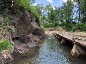
Former city water intake structures contribute to erosion and
sedimentation at the mouth of the East Branch
Former City water intake structures contribute to erosion and
sedimentation at the mouth of the East Branch

During construction, hydraulic hammer assists with dam
remnant removal
Chagrin River & East Branch Restoration
At Daniels Park, the East Branch joins the Chagrin River before it flows five miles northward to Lake Erie. Although the East Branch is a state-designated Scenic River and the Chagrin River is relatively healthy in this area, the rivers’ health is threatened. Sediment and nutrient pollution caused by riverbank destabilization and habitat alterations are threats to aquatic animals such as fish and macroinvertebrates. The pollution is also a concern for the health of Lake Erie, which supplies drinking water for over 11 million people.
Thanks to a $2.2 million grant awarded to Chagrin River Watershed Partners from the Ohio Department of Natural Resources (ODNR) through the state’s H2Ohio Initiative, Chagrin River habitat will be improved and the river corridor will be protected at the City of Willoughby’s Daniels Park and adjacent lands.
Dam remnants will be removed from the Chagrin River, eroding riverbanks will be stabilized along the Chagrin River south of Johnnycake Ridge Road, and the East Branch of the Chagrin River will be restored to a more stable configuration to reduce erosion and sedimentation south of Johnnycake Ridge Road. Seventy-eight (78) acres of land will be protected within the Chagrin River and East Branch corridors, including high quality wetlands. Wetland habitat will also be created in the former channel of the East Branch to create habitat for spawning fish, waterfowl, and native plant species. Upon completion, the project will improve the health of the Chagrin River, reduce sediment and nutrient pollution to Lake Erie, improve fish habitat for salmonid species such as steelhead, increase safe and public access to the river, and enhance connections to other protected areas in the Chagrin River corridor.
In addition to working together on this H2Ohio project, the Chagrin River Watershed Partners, the Western Reserve Land Conservancy, and the City of Willoughby are working with many other local and regional partners to develop a Chagrin River Corridor and Lakefront Trail Connection plan in western Lake County. This trail planning and public access initiative is funded by the Cleveland Foundation’s Lake Geauga-Fund and in collaboration with the Northeast Ohio Areawide Coordinating Agency and support from 26 local partners and communities. The plan will be completed in the coming months. The land protection components of the H2Ohio project will ensure that the Chagrin River corridor in this area will be protected from development, ready for connection to the new trail network, and someday opened to the public for recreational access to the Chagrin River and Lake Erie.
Additional information:
- Restoration and Reconnection Along Ohio's Chagrin River video
- Daniels Park stream restoration planning webpage
Funders and Partners:
- Continue to project story map